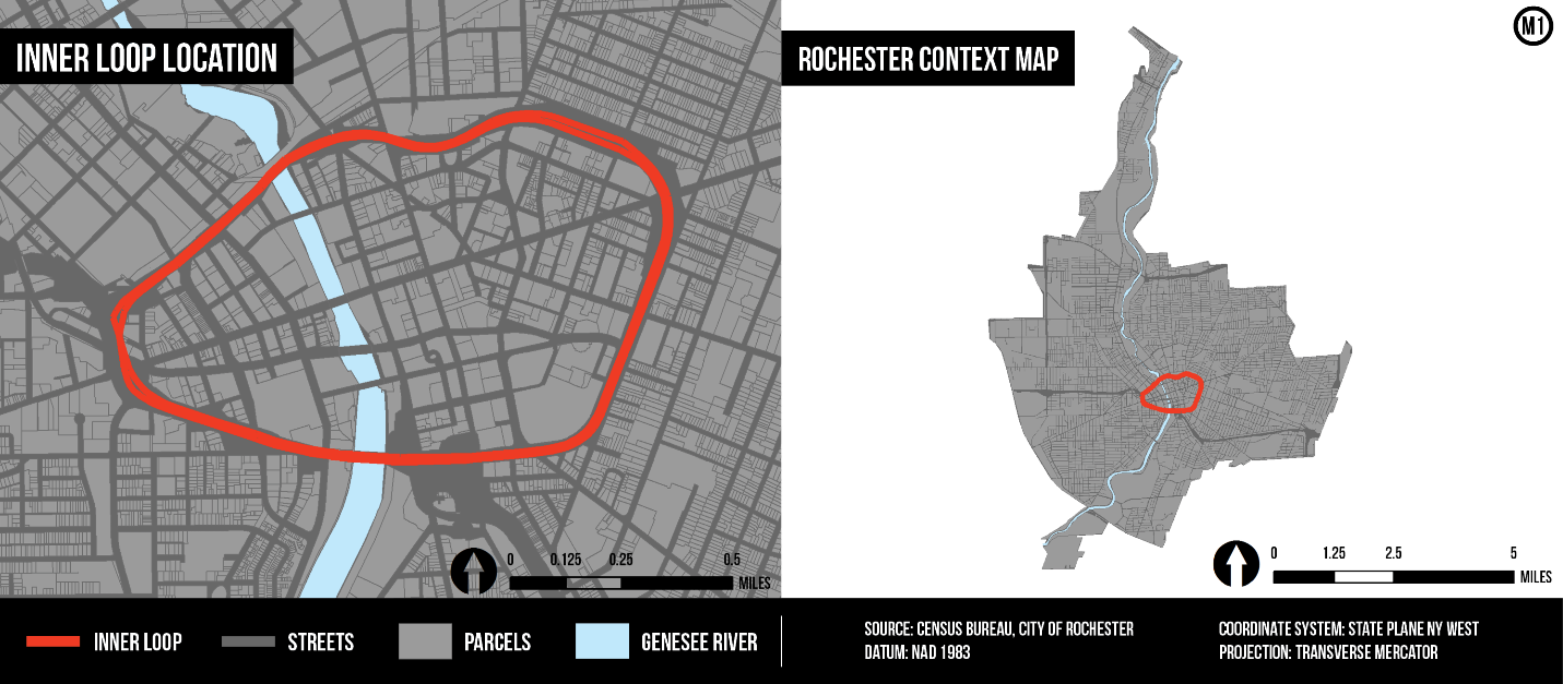
In the early 1950s, planners in Rochester, New York made a decision that would impact transportation and development in the city for the next half-century. At the time, both the city’s population and the popularity of the automobile were increasing exponentially, meaning that traffic congestion through downtown was becoming particularly unmanageable. To relieve some of this congestion, the city followed the prevailing planning sentiment at the time and constructed an urban beltway known as the Inner Loop – a three-mile ring of sunken highway surrounding the central business district.
Years later, following innovations and new information on urban planning, it is increasingly apparent that urban beltways act like moats that divide rather than arterials that connect. Hindsight aside, the intentions of the mid-century planners were admirable and, in a time when auto-centrism was a goal to achieve and not a mistake to correct, the planners must have viewed the Inner Loop as a step towards Wright’s futuristic and car-dependent Broadacre City. In their own words, the planners lauded the Inner Loop as the “formula that will save the business district from self-strangulation” by effectively circulating traffic around downtown.
The Paradox: Constructing Inequality
Ironically, the Inner Loop itself has become the instrument of strangulation and is now colloquially, if not aptly, referred to as the “Inner Noose” since it physically and metaphorically separates the center city from the surrounding neighborhoods. Aerial imagery attests to this spatial separation but visualizing the economic consequences requires the enumeration and subsequent analysis of Census data. By mapping this data, it is possible to expose otherwise intangible spatial relationships between the Inner Loop and surrounding neighborhoods. The following spatial and quantitative analysis explores the effect of the Inner Loop on the physical development of the city and the economic development of the surrounding neighborhoods.
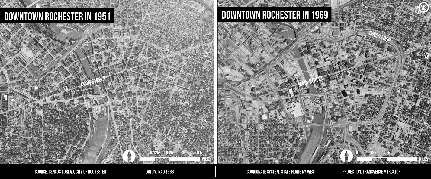
Before the construction of the Inner Loop, the street network in downtown Rochester was dominated by the east-west axis of Main Street, off which other north-south streets radiated. Together, these streets created an irregular grid that was further complicated by the Genesee River. The River, which bisected the center city, concentrated traffic at the limited number of bridges where one could travel to and from the east and west sides. Traffic benefited from the introduction of the automobile but, as the private car increased in popularity, traffic problems again reemerged. To divert traffic from Main Street, the preferred bridge across the Genesee River, an alternate east-west thoroughfare was constructed but it was never as heavily trafficked as the city intended. Even the elimination of on-street parking during rush hours could not relieve the congestion.
Evidently, the automobile was the crux of the problem in Rochester and the “dual task of keeping it moving freely and permitting it to park conveniently prompted the construction of the Inner Loop.” As the ostensibly omniscient narrator of a 1963 Rochester promotional video proclaims, “Times change and you either change your city to fit them or they’ll change your city, often unpleasantly.” Rochester ultimately acquiesced with the whims of the automobile, increasing capacity and facilities for it rather than providing alternatives to it. Since the 20th century was geared toward the automobile, so too was Rochester.
The Inner Loop undoubtedly resulted from Rochester’s emphasis on auto-centrism, with this “capacious new traffic artery” being another provision to support the flow of traffic. By encircling downtown, the Inner Loop ensured that through-traffic need not pass through the center city to cross the River, thereby offering improved accessibility and additional convenience. Such convenience was underscored by the claims of that promotional video: “[In Rochester], driving is the positive pleasure it ought to be everywhere.”
What was not particularly convenient about the Inner Loop was its construction. In order for the beltway to be built, “huge swaths of land had to be acquired and [hundreds] of buildings had to be condemned and destroyed.” Along the east side of the River, for instance, more than 160 houses were condemned and many of those displaced were “unable to find other more desirable accommodations” according to a study by the Council of Social Agencies.
Post-construction aerial imagery shows how the Inner Loop ripped through downtown Rochester, disrupting the existing street network and disconnecting tightly knit neighborhoods (Map 2). Considering the enduring impacts of large infrastructure projects, the Inner Loop essentially created an un-mendable seam in the city’s urban fabric, leaving a gash that still scars the landscape some sixty years later. The project was similarly enduring in terms of cost; it took the City nearly two decades to secure funding to remove less than one-third of the beltway.
The economic consequences resulting from the spatial separation of the Inner Loop still persist to this day and are evident in the distribution of poverty, unemployment, and income throughout the city. The Inner Loop quite literally shaped this distribution, in part creating and exacerbating conditions in the Crescent of Poverty – a conglomerate of Census Tracts with high concentrations of poverty adjacent to the northwestern portion of the beltway. It seems more than mere coincidence that this concave, crescent-shaped area tessellates so perfectly against the convex ring of the Inner Loop (Figure 1).

Since the Inner Loop is below-grade, or below street level, it acts as “a moat that separates the neighborhoods from downtown.” As in medieval lore, this contemporary moat restricts connectivity and limits accessibility to the economic and job opportunities that the moat surrounds. A concrete testament to the City’s experiment with auto-centrism, the Inner Loop essentially renders travel by any mode other than automobile unviable. Amenities and opportunities that were once within walking or biking distance are no longer. For residents in the Crescent of Poverty, these physical barriers result in economic barriers as well.
The Crescent of Poverty, which was limited to six Census Tracts (2, 13, 41, 92, 93.01, and 96.04) for the purposes of this analysis, contains some of the poorest neighborhoods in Rochester (Map 3).
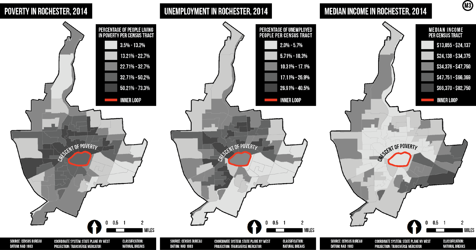
Though the entire City of Rochester experiences above average poverty rates, the Crescent of Poverty experiences the most exaggerated rates, with anywhere from fifty to seventy-three percent of residents living below the poverty line compared to an average of only thirty-one percent for the city (Figure 2).
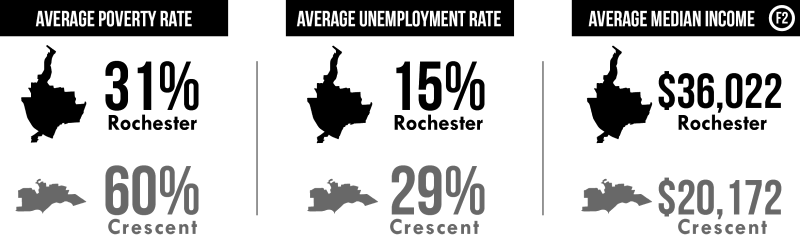
The prevalence of poverty in the Crescent, as opposed to the southeastern neighborhoods, might result from the fact that neighborhoods in the Crescent are interrupted by large industrial complexes rather than being predominantly residential. This suggests that residents in the Crescent were likely reliant upon the jobs offered by these once-thriving industries. In the post-industrial era, however, the Census Tracts in the Crescent of Poverty have nearly double the average unemployment rate (twenty-nine percent) compared to the city as a whole (fifteen percent). Furthermore, the restricted mobility induced by the Inner Loop effectively cuts off Crescent residents, many of whom are unable to afford cars, from the job opportunities that exist downtown. As a result, the average median income in the Crescent of Poverty ($20,172) is more than forty-four percent lower than that in the city ($36,022). One might feel compelled, however, to dismiss these consequences as incidental to progress so long as the Inner Loop achieved its intention of reducing traffic.
In this regard, the Inner Loop succeeded but did so excessively. As a sunken highway, the Inner Loop minimized pedestrian and vehicular cross-traffic, ensuring that drivers could circle the city at forty-five miles per hour without having to stop at traffic lights, stop signs, or crosswalks. In effect, the Inner Loop became an “evacuation route,” quickly speeding residents out of downtown and into the suburbs, compounding sprawl, and reducing the inner city population. In fact, Rochester’s population declined almost thirty-four percent from 318,611 in 1960 (during the Inner Loop’s construction) to 210,401 in 2010 while the population of the surrounding county grew by nearly twenty-seven percent during the same time period. Though factors other than the construction of the Inner Loop undoubtedly contributed to the city’s stagnating population, it seems that this reduction in population – and not the construction of the Inner Loop – was the primary reason for the subsequent reduction in inner city traffic.
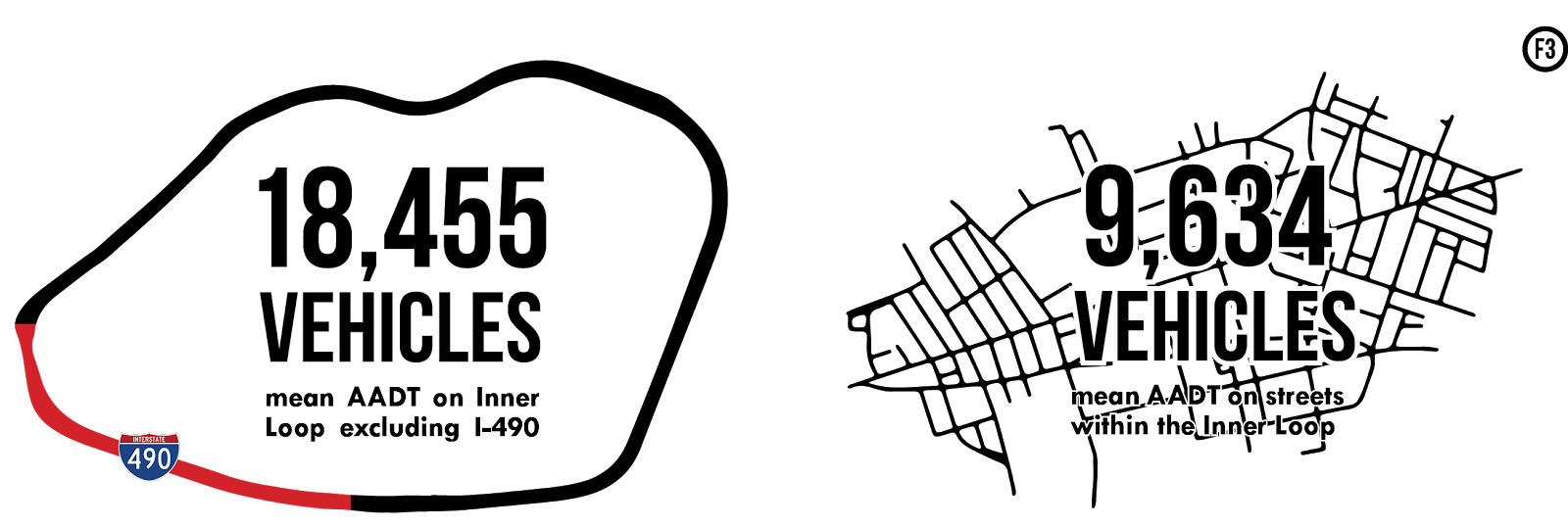
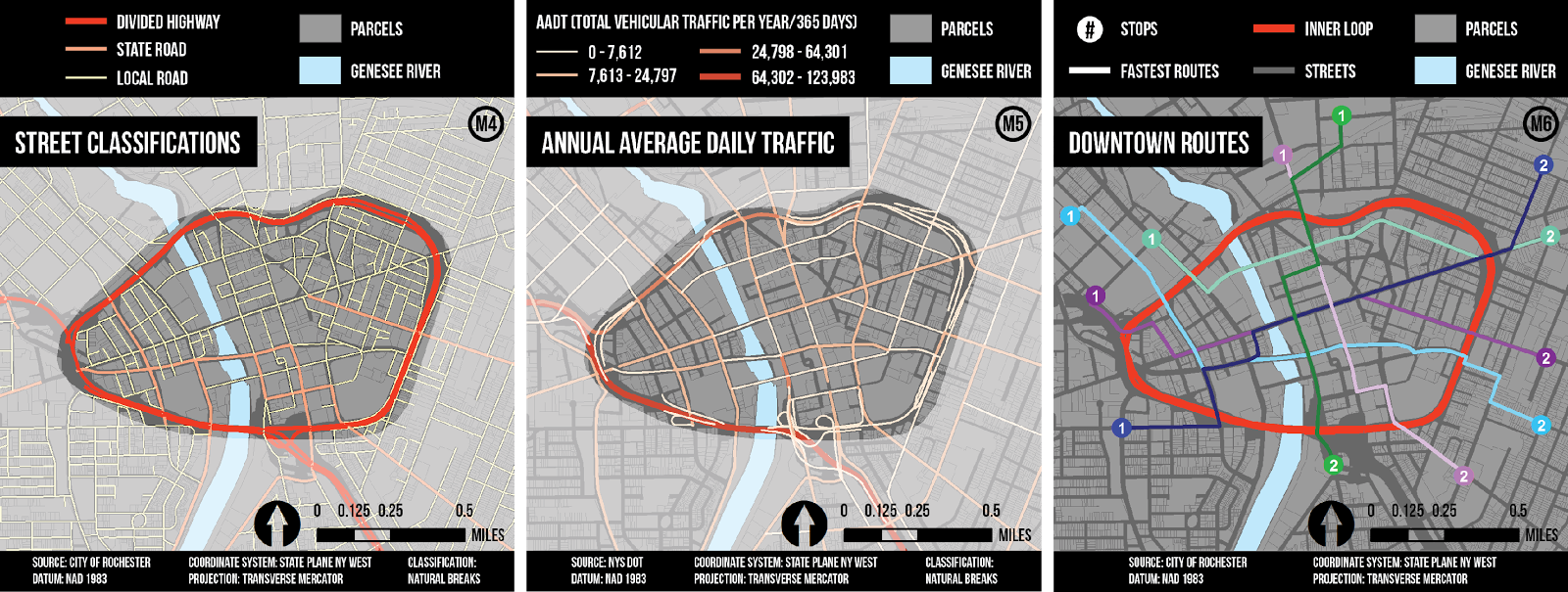
Today, the Inner Loop’s unimpeded route remains relatively underutilized. On some portions of the Inner Loop, the average daily traffic volume (also referred to as the annual average daily traffic, or AADT) is no greater than that on the local and state routes within the beltway (Maps 4 and 5). (It should be noted that the southwestern portion of the Inner Loop is also part of Interstate-490, a highly traveled connector between the city and the New York State Thruway, which accounts for the substantial traffic volume along this portion of the Inner Loop.) Overall, the Inner Loop (excluding the I-490 portion) has an average daily traffic volume twice as large as that on the streets within the Inner Loop, though neither measure is particularly high for a city the size of Rochester (Figure 3).
In addition to relatively low traffic volumes along the Inner Loop, mapping the fastest routes between destinations indicates that it is often more efficient to avoid the Inner Loop when traveling through and across downtown (Map 6).
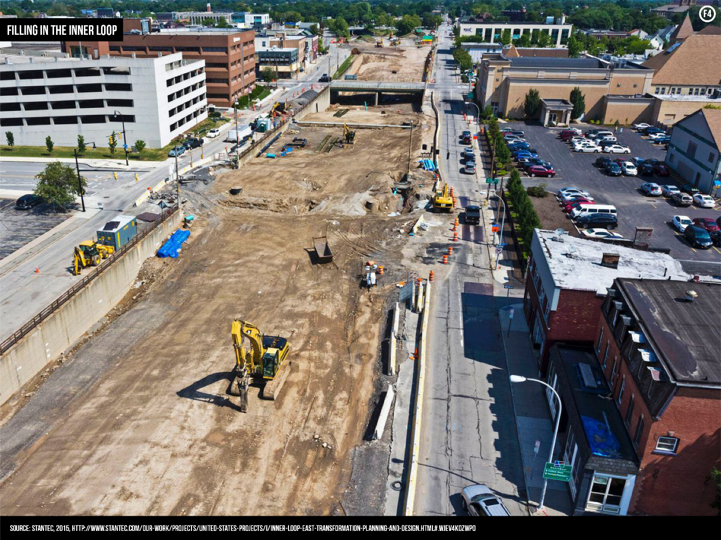
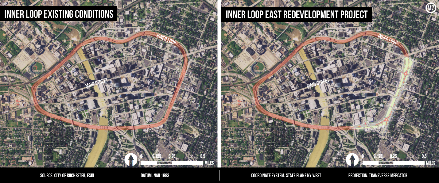
Low traffic volumes attest to the fact that the need for the Inner Loop is no longer salient and, consequently, the City has begun filling in the eastern and least-traveled portion of the beltway to create a more walkable, surface-level boulevard (Figure 4).
The redeveloped boulevard will condense the Inner Loop’s excessive six- and four-lane segments to three lanes with wide sidewalks, bike lanes, and on-street parking (Map 7). Additionally, for the first time since the Inner Loop’s construction, north-south streets will be reconnected for two-way traffic. Rochester Mayor Lovely Warren views the Inner Loop East Redevelopment Project as a means to improve connectivity, produce jobs, and provide more space for expanding businesses, housing, and development. Upon its completion in 2017, this boulevard is projected to see more traffic than its predecessor as a result of these new developments.
Such development is particularly and arguably more imperative along the northwestern portion of the Inner Loop near the Crescent of Poverty. Filling in this portion of the Inner Loop might attract much-needed investment and create economic opportunity for residents in this area. Though Mayor Warren has encouraged the City Council to initiate construction on the northwestern Inner Loop, this project might encounter opposition as, aside from the I-490 portion of the Inner Loop, the northwestern Inner Loop has the highest daily traffic volume. However, there are numerous examples of cities like New York, Portland, and San Francisco removing urban freeways and experiencing a subsequent decrease in traffic congestion. Furthermore, low traffic volumes along the streets within the beltway indicate that these streets have additional, unused capacity to absorb any traffic displaced by the removal of the northwestern portion of the Inner Loop. Thus, removing this portion of the Inner Loop would divert traffic to previously underutilized streets while reconnecting the neighborhoods in the Crescent of Poverty to the economic opportunity that exists in the central business district. Though the construction of the Inner Loop severed downtown Rochester from its surrounding neighborhoods, the redevelopment of the Inner Loop has the potential to reconnect Rochester by “enhancing the area’s livability [and] allowing people to easily walk and bicycle between neighborhoods and downtown.”
The far-reaching temporal and spatial consequences of the Inner Loop serve as an important reminder of the permanence of transportation infrastructure. In the words of urban theorists Rittel and Webber: “One cannot build a freeway to see how it works, and then easily correct it after unsatisfactory performance.” The physical and economic effects of the Inner Loop will continue to permeate into the foreseeable future, ultimately informing the City’s transportation and development policies for years to come. While it might not be entirely possible to reverse the effects of the Inner Loop, it is possible to craft tactful policy based on lessons learned from Rochester’s self-inflicted noose.
Tags: New York State , Poverty , Inequality